Ingenious Bran
Civil CAD Drawings

We provide civil CAD drawing services for construction projects ranging from buildings, roads/motorways, railways, dams, retaining walls, tunnels and bridges. We also provide complete drawing support for environmental elements such as water supply, river/coastal protection, drainage, sewage treatment, and flood alleviation and pollution control.
Civil
We provide a professional CAD drafting and detailing service to a range of clients. Our core areas of activity remain building services drafting, architectural detailing and civil & structural drawing support, these along with all other areas supported are detailed below: Building Services - We provide spatially co-ordinated electrical, HVAC, public health and pipe work drawings to M&E consulting engineers and contractors. We work on all phases of M&E projects from tender, comment, working, construction and record drawings. Our experience spans a range of sectors such as retail, transport, health care, commercial and industrial sectors.
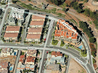
Parcel / Tax mapping
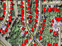
Ingenious Bran can provide catalog imagery layers from multiple sources to create the base map your company needs. Everything from high-resolution aerial photography to multi spectral satellite imagery is utilized to bring the information and features you need into focus. Parcel Maps were digitized and parcel numbers were attributed to each parcel polygons. Details like dimensions of each side and the connectivity of Manholes were captured.
Individual parcel line maps contain line work and text only. Included in the information shown on a standard parcel map are: parcel identification numbers, parcel and lot dimensions, streets and street names, as well as various other data typically used in property location and identification.
Users can look at graphic data as well as related attribute data at the same time Map production will be much easier and faster. Map output can be standardized throughout the organization. Users can plot maps by themselves. There is no need for preparing data every time since data is stored in GIS data library. Simple Search or query of Database and Maps. With this tracking of historic data and map updating can be immediate.